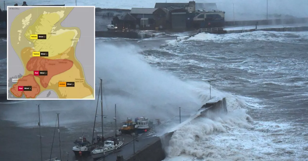
The Met Office has issued a rare red weather warning for Scotland as Storm Éowyn is set to bring destructive winds of up to 100mph, heavy rainfall, and potential snow. The warning, the most extreme level issued, covers a wide area from Eyemouth on the east coast to the Isle of Mull in the west and down to the southwestern tip of Scotland. Millions of Scots are being warned to prepare for 'danger to life' conditions as the storm is expected to cause widespread disruption to travel, power supplies, and infrastructure.
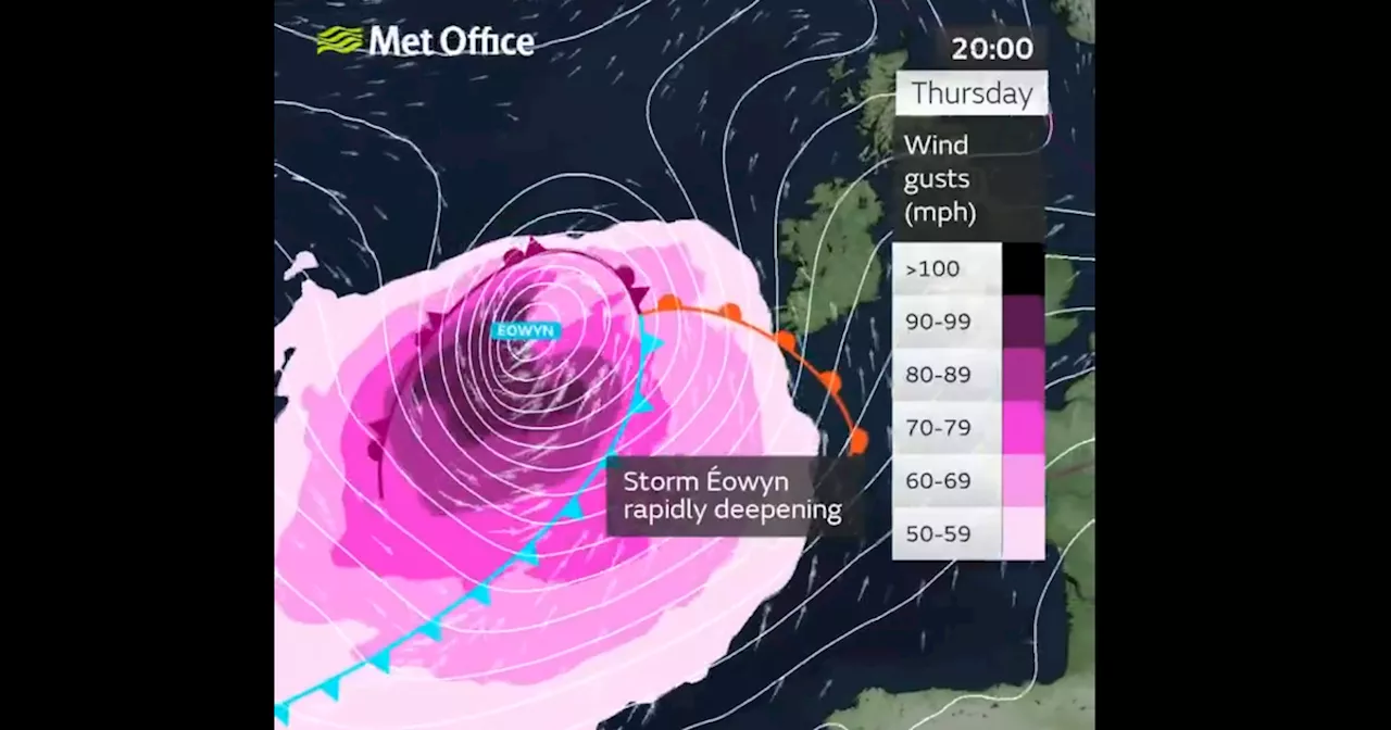
The Met Office has issued a rare red weather warning as Storm Éowyn is set to batter Scotland tomorrow. An Atlantic jet stream is bringing the destructive weather front to the UK's shores in the early hours of Friday, January 24th. The national forecaster has put a number of weather alerts in place over the coming days, with this latest red warning representing the most extreme level.
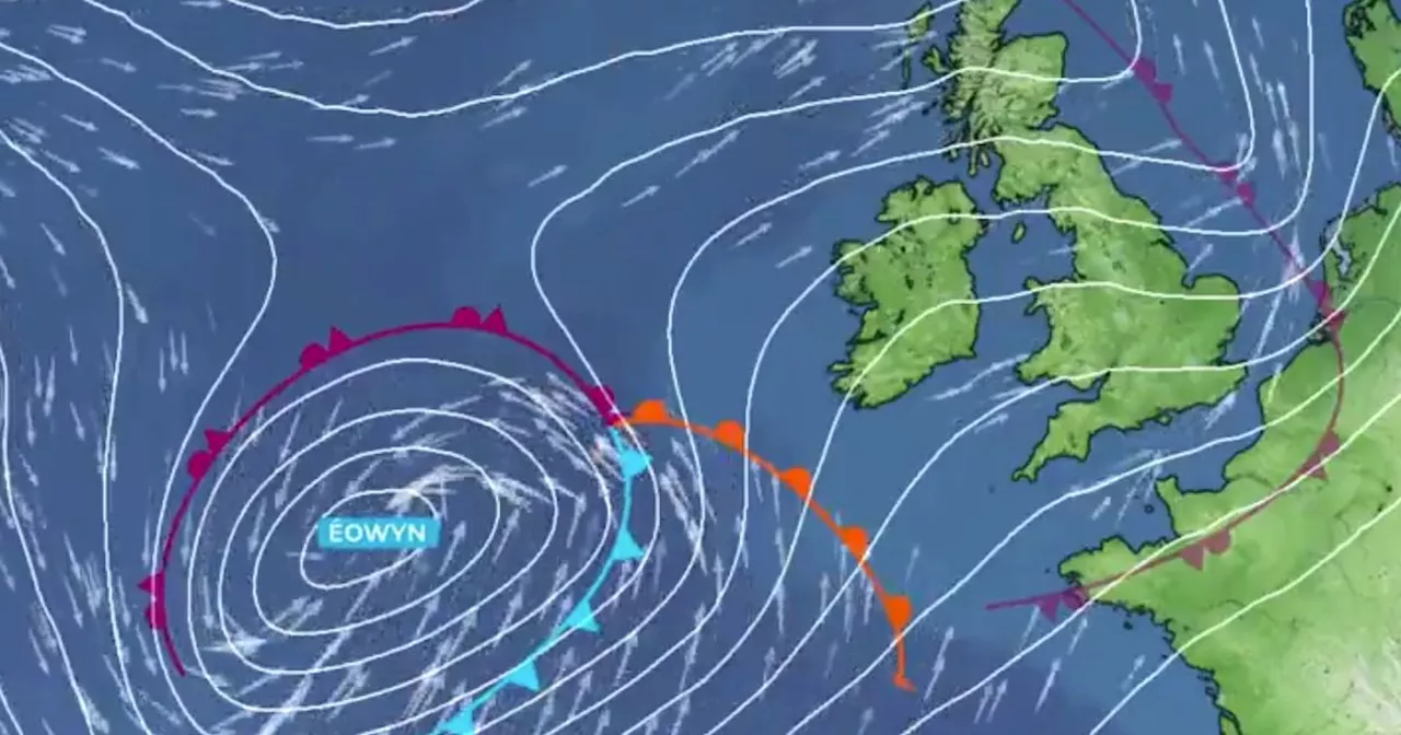
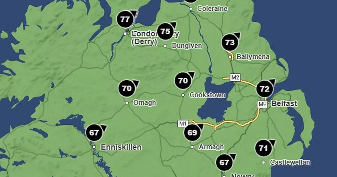
The Met Office predicts there is a high likelihood of the warning area being hit and anticipates a high impact when it does. Storm Éowyn's gusts are expected to reach up to 100mph in some areas, causing 'very dangerous conditions and significant disruption'. The red alert is in place from 10am on Friday, January 24th, until 5pm that day. The warning area stretches from Eyemouth on the east coast to the Isle of Mull off the west coast and down to the southwestern tip of the country past Stranraer. The majority of the Central Belt is within the danger zone, including Glasgow and Edinburgh, meaning millions of Scots will have to brace themselves for the 'danger to life' that Storm Éowyn will bring. The winds will 'rapidly increase' during Friday morning into the afternoon, with most areas within the red zone experiencing winds of 80-90mph and highs of 100mph on the exposed west coast. Flying debris will put lives at risk, as will huge waves crashing onto seafronts and coastal roads. Power cuts are expected across various regions, with damage to buildings and homes predicted too. Storm Éowyn, pronounced ‘Ay-oh-win’, will cause 'very dangerous driving conditions', according to the Met Office, with road closures to be expected. Delays and cancellations are highly likely for those looking to travel by rail, air, or ferry. Met Office Chief Meteorologist Paul Gundersen said: “We reserve the issuing of red warnings for the most severe weather which represents a likely danger to life and severe disruption, and that is the case with Storm Éowyn. “While it will be widely very windy on Friday, with additional hazards from rain and snow, the strongest winds and most significant impacts are likely in Northern Ireland and central and southwestern parts of Scotland within the red warning areas, where winds could gust 80-90 mph quite widely for a time, and potentially up to 100 mph for exposed coasts in particular.” As well as the galeforce winds, Storm Éowyn is expected to bring heavy rainfall and even snow. A yellow warning for snow is in place for northern Scotland from 6am on Friday until midnight. Met Office Chief Meteorologist Paul Gundersen continued: “Storm Éowyn is a multi-hazard event, with snow likely for some, rain for many and strong winds for much of the UK. As a result, a number of weather warnings have been issued, with all parts of the UK covered by one warning at some point on Friday. “Storm Éowyn is expected to cross Northern Ireland early on Friday morning. It will then continue northeast across the northern half of Scotland during Friday afternoon and is expected to be centred near Shetland during Friday evening. “It’s important to note that even those away from the immediate Red Warning areas will still likely see disruptive weather, with travel plans likely to be severely impacted, as well as the possibility of power cuts for some.” Regions and local authorities affected by the Met Office red warning: Central, Tayside & Fife SW Scotland, Lothian Borders Strathclyde Don't miss the latest news from around Scotland and beyond. Sign up to our daily newsletter.
Storm Éowyn Met Office Red Weather Warning Scotland Wind Heavy Rainfall Snow Travel Disruption Danger To Life
United Kingdom Latest News, United Kingdom Headlines
Similar News:You can also read news stories similar to this one that we have collected from other news sources.
 Storm Éowyn LIVE as Met Office issue red warning for Northern IrelandThe storm is set to bring 'widespread disruption' with decisions yet to be made on school closures and travel
Read more »
 Scotland's cold spell coming to an end, say Met Office despite -13C overnightThe mercury has barely been above zero in parts of the country over the last few days.
Read more »
 Storm Éowyn to bring 80mph winds to UK as Met Office issues 'severe' warningA yellow weather warning for wind has been issued
Read more »
 Met Office warns Storm Éowyn will bring 'very strong winds' to NottsThe storm is expected to batter most of the UK later this week
Read more »
 Met Office warns 'storm' could hit UK with 'powerful Jet Stream'The UK is set to experience more unsettled weather next week
Read more »
 Met Office names storm set to hit Northern Ireland this weekIt will cause disruption to travel, with road, rail, airports and ferries likely to be affected
Read more »