The latest weather forecast for New England includes windy conditions, snow flurries, and a clear view of the Eta Aquarids meteor shower.
However, each day it decreases a bit. Wind damage and outages were found across New England from Thursday’s winds of 50-60 mph in some spots. In fact, Boston saw a 58 mph gust on Thursday. On Friday, we expect winds to peak around 40 mph from the west/northwest. That means our wind chills will be in the teens and 20s even though our highs top off in the 30s.
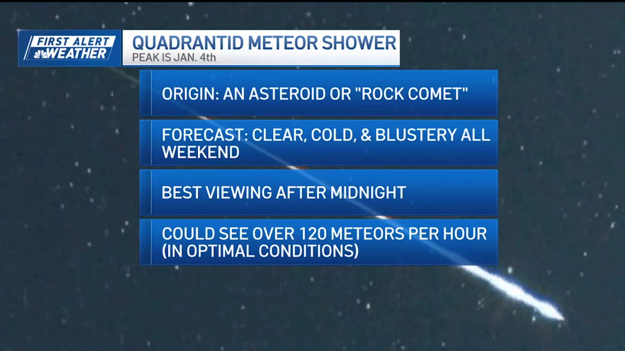
And the snow bands stretch as far east as western New England! Flurries will fall around our towns, but we're not expecting accumulation from that particular setup. It’s the upslope snow that brings us additional light snowfall in the mountains through Saturday. Meteors are also ongoing right now. The origin of these meteors is from an asteroid or “rock comet” called 2003 EH1. As the Earth passes through the debris trail from this now dead comet, our sky lights up. The peak is overnight Friday, as we could see up to 120 meteors per hour in peak, optimal conditions. The next few nights will be blustery and clear to view the shooting stars. Highs this weekend fall a bit more to the low 30s both Saturday and Sunday, with sun and less of a wind on Sunday. A large storm passes well to our south on Monday, so the northeast again misses out on snowfall. Areas along the Interstate 70 corridor from Kansas to the Appalachians will get several inches of snow this weekend, and an ice storm will impact parts of southern Missouri, southern Illinois, southern Indiana, all of Kentucky, northern Tennessee, into the mountains east. That low pressure center heads out to sea, with a miss in New England, but we'll see increasing winds by Tuesday as it departs to the northeast
Weather Forecast New England Wind Snow Flurries Eta Aquarids Meteor Shower
United Kingdom Latest News, United Kingdom Headlines
Similar News:You can also read news stories similar to this one that we have collected from other news sources.
 New Year's Eve Rain and Chilly New Year in Store for New EnglandNew Year's Eve will be dry with mild temperatures until midnight when showers begin and last through New Year's Day. A colder air mass moves in Wednesday bringing snow to northern New England. Strong winds expected Thursday combined with snow could cause power outages and damage. Lake-effect and ocean effect snow possible northwest and off the coast, but much of New England will see a dry, sunny, and chilly weekend. A potential storm next week could bring rain and snow to southern New England.
Read more »
 New England to Escape Arctic Chill, but Rain May Dampen New Year's EveAfter several days of frigid temperatures, New England is set to see a warming trend with highs reaching the 40s and 50s. However, a storm system approaching on Monday could bring rain, potentially impacting New Year's Eve celebrations.
Read more »
 New England Law Enforcement on High Alert After New Orleans AttackMassachusetts and New Hampshire state police are increasing security measures after a driver killed 10 and injured 30 in New Orleans' French Quarter. The incident is being investigated as a potential terrorist attack. While there's no known threat to New England, authorities urge vigilance and reporting of suspicious activity.
Read more »
 Snowstorm could bring 8+ inches of snow to parts of New EnglandA snowstorm moves into Massachusetts overnight, bringing nearly a half a foot of snow to parts of New England. Here are the latest snowfall totals.
Read more »
 New Zealand v England: Ben Stokes backs opener Zak CrawleyEngland captain Ben Stokes backs opener Zak Crawley to improve his dismal record against New Zealand in the second Test in Wellington.
Read more »
 New Zealand vs England second Test: What to watch out for in WellingtonEngland can secure their first series win in New Zealand since 2008 if they win the second Test in Wellington - Stephan Shemilt picks five things to look out for.
Read more »