
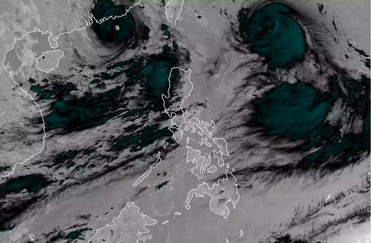
Typhoon Hanna has maintained its strength as it continued to move 15 kph westward over the Philippine Sea. According to the tropical cyclone bulletin released at past 11 p.m. on Friday, the eye of the storm was last seen 595 kilometers east northeast of Basco, Batanes. It has with maximum sustained winds of 120 kph and gustiness of up to 150 kph. For the rest of the forecast period, Hanna is anticipated to move generally westward or west northwestward, but a possible southward shift in the forecast may cause the hoisting of tropical cyclone wind Signal No. 1 over Batanes. Hanna is expected to exit the Philippine Area of Responsibility and emerge over the Taiwan Strait between Sunday evening to Monday morning as a severe tropical storm or a minimal typhoon. No tropical cyclone wind signals have been raised, but the typhoon continues to enhance the Southwest Monsoon along with Typhoon Soila and Severe Tropical Storm Kirogi just outside the Philippine Area of Responsibility. As a result of the enhanced Southwest Monsoon, occasional to monsoon rains over the western portion of Luzon is to be expected within the next three days. Gusty conditions have also been forecast in the following areas: Friday to Sunday: Batanes, Babuyan Islands, Ilocos Region, Cordillera Administrative Region, Nueva Vizcaya, Zambales, Pampanga, Bataan, Aurora, Bulacan, Metro Manila, CALABARZON, MIMAROPA, Bicol Region, Western Visayas, and the northern portion of Eastern Visayas. Monday: Batanes, Babuyan Islands, Ilocos Region, Cordillera Administrative Region, Nueva Vizcaya, Zambales, Pampanga, Bataan, Aurora, Bulacan, Metro Manila, CALABARZON, and most of Bicol Region, MIMAROPA, and Western Visayas. A gale warning is also in effect for most seaboards of Luzon and Western Visayas, and the seaboard of Northern Samar due to the enhanced Southwest Monsoon.
Typhoon Hanna has maintained its strength as it continued to move 15 kph westward over the Philippine Sea.
Hanna is expected to exit the Philippine Area of Responsibility and emerge over the Taiwan Strait between Sunday evening to Monday morning as a severe tropical storm or a minimal typhoon. As a result of the enhanced Southwest Monsoon, occasional to monsoon rains over the western portion of Luzon is to be expected within the next three days.Friday to Sunday: Batanes, Babuyan Islands, Ilocos Region, Cordillera Administrative Region, Nueva Vizcaya, Zambales, Pampanga, Bataan, Aurora, Bulacan, Metro Manila, CALABARZON, MIMAROPA, Bicol Region, Western Visayas, and the northern portion of Eastern Visayas.
United Kingdom Latest News, United Kingdom Headlines
Similar News:You can also read news stories similar to this one that we have collected from other news sources.
 FACT CHECK: Hindi super typhoon ang bagyong Hanna, walang Signal No. 5Sa kasalukuyan, walang wind signal warning na nakataas sa alinmang bahagi ng bansa dahil sa Bagyong Hanna
Read more »
 Hanna intensifies into typhoon —PAGASATropical Cyclone Hanna has intensified into a typhoon and is now enhancing the Southwest Monsoon or Habagat
Read more »
 Hanna strengthens into typhoon, still enhancing southwest monsoonTyphoon Hanna (Haikui) is 785 kilometers east northeast of Itbayat, Batanes, on Friday morning, September 1. The enhanced southwest monsoon is still bringing rain.
Read more »
 Hanna to be a typhoon on Friday, seen to enhance Southwest MonsoonSevere Tropical Storm Hanna continued to move 20 kph on its west northwestward path over the Philippine Sea, according to PAGASA’s 11:00 PM cyclone bulletin on Thursday.
Read more »
 Super Typhoon Goring out, Severe Tropical Storm Hanna inThe southwest monsoon is still being enhanced by Goring (Saola) despite the super typhoon's exit, and also slightly enhanced by Severe Tropical Storm Hanna (Haikui)
Read more »