
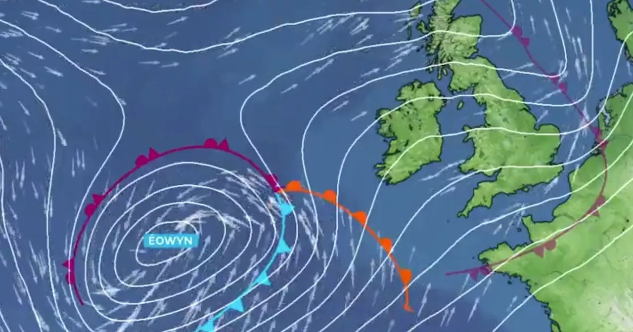
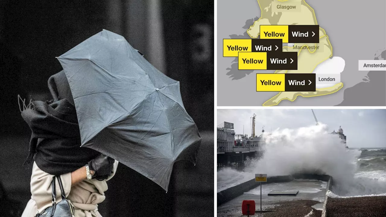
The Met Office has named Storm Éowyn, forecasting 80mph winds and 30mm of rain across the UK. Areas most affected include Northern Ireland, northern England, northwestern Wales, and western Scotland. Strongest winds are expected on exposed coasts, prompting Yellow Severe Weather Warnings. The storm will bring heavy rain, with potential for snow over high ground, especially in Scotland. Heavy rain will move eastwards from Thursday, with Éowyn's influence starting on Friday. Drivers are urged to exercise caution due to expected challenging driving conditions.
Storm Éowyn has been named by the Met Office as forecasters say to expect 80mph winds and 30mm of rain, and some will get snow. The weather service says to expect the highest winds on exposed coasts in Northern Ireland, northern England, northwestern Wales and western Scotland, with Met Office Yellow Severe Weather Warnings issued and further updates likely in the coming days.
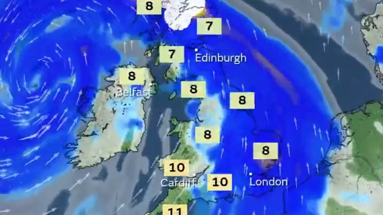
Storm Éowyn, pronounced ‘ay-oh-win’, will begin to influence the UK’s weather early on Friday, with strengthening winds initially in southwestern parts of the UK with accompanying heavy rainfall. This will quickly spread northeast to the rest of the UK during Friday morning. There is also a chance of snow over Northern Ireland, northern England and Scotland as the system initially bumps into cold air, however much of this will quickly change to rain as milder air moves in.
“The initial warning for Storm Éowyn has been issued several days in advance, so it’s important to stay up to date with the forecast as further details emerge in the coming days.” “Drivers also need to be well aware of the buffeting effect of sudden gusts, especially along coastlines and exposed areas where the worst weather is expected. High-sided vehicles are most at risk of being blown off course, but cars can also be affected as they pass lorries on the motorway and are then hit by the wind on the other side. It’s best to keep speeds low and have a firm grip on the wheel to avoid being caught off-guard, especially in areas where heavy rain will affect visibility.
STORM WIND RAIN SNOW UK WEATHER
United Kingdom Latest News, United Kingdom Headlines
Similar News:You can also read news stories similar to this one that we have collected from other news sources.
 Storm Éowyn officially named as 80mph winds and snow set to batter ScotlandStorm Éowyn is set to hit our shores in the early hours of Friday morning.
Read more »
 Storm Éowyn named by Met Office as 80mph winds set to batter the UK this weekendStorm Éowyn is set to bring winds of up to 80mph across the UK on Friday and Saturday, the Met Office has warned.
Read more »
 Storm Éowyn to bring 80mph winds to UK as Met Office issues 'severe' warningA yellow weather warning for wind has been issued
Read more »
 Storm Éowyn to Batter UK with 80mph Winds, Bringing Travel Chaos and Potential DangerThe UK braces for Storm Éowyn, the fifth named storm of the season, which is set to unleash winds of up to 80mph across the country. The Met Office has issued severe weather warnings with potential for building damage, flying debris, power cuts, and travel disruption. Coastal residents are warned of large waves posing a risk to life.
Read more »
 Storm Éowyn to Batter UK with 80mph Winds and Travel ChaosStorm Éowyn, the fifth named storm of the season, is set to bring strong winds, travel disruption, and potential coastal dangers to the UK.
Read more »
 Storm Éowyn to Bring 80mph Winds and Disruption to UKThe Met Office has named the approaching storm Éowyn, which is set to bring 80mph winds, heavy rainfall, and snow to the UK this Friday. A yellow wind warning has been issued for most of the country, with the potential for damage to buildings, transport disruption, and power cuts. The storm is being fueled by a supercharged Jet Stream caused by a clash of Arctic and tropical air.
Read more »