The Met Office has named the fifth storm of the 2024/25 season, Éowyn, and warned of 80mph winds, heavy rainfall, and snow across the UK this weekend. The storm, brought on by a 'supercharged' jet stream, is expected to cause significant disruption from Friday to Saturday.
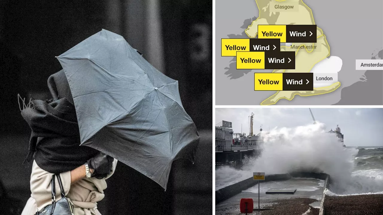
The Met Office named the impending storm Éowyn, predicting 80mph winds to bring chaos across the UK this Friday. The storm, the fifth of the 2024/25 season, follows Darragh, Conall, Bert, and Ashley. A yellow wind warning initially issued for Scotland and northern England, covering midnight Friday to midday Saturday, has been expanded to encompass most of the UK, excluding London and the South East.
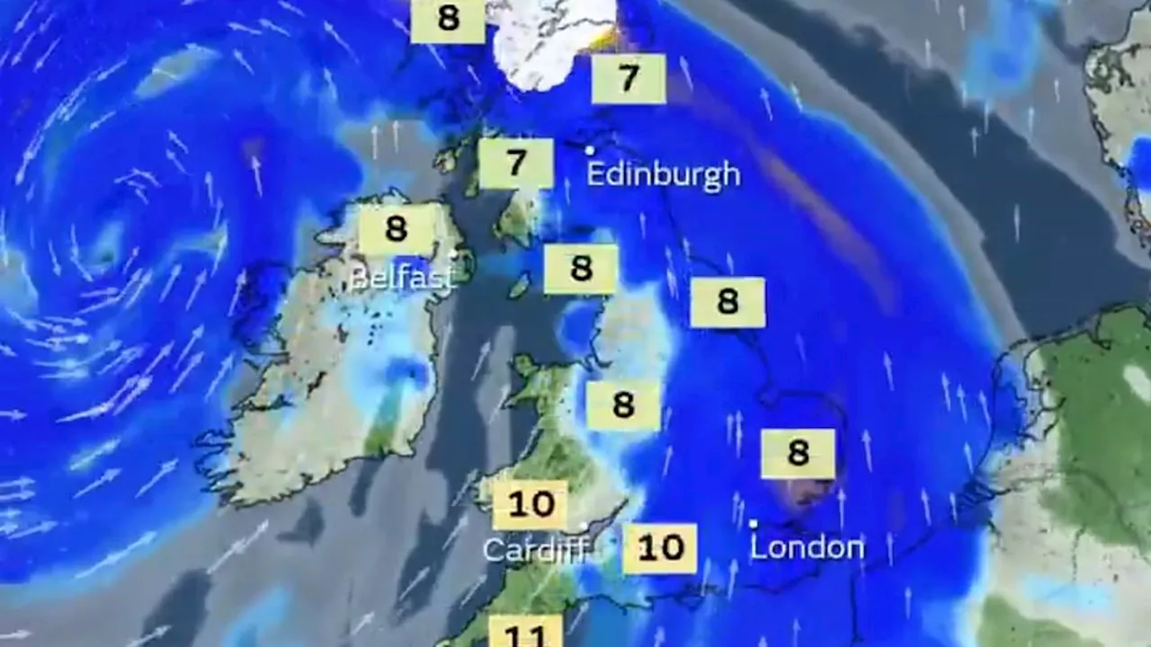
Unsettled conditions are expected to commence on Thursday, with strengthening winds and heavy rainfall in western regions overnight. This shift follows the relatively calm, cloudy weather with scattered showers experienced by much of the country earlier this week. The 80mph winds are anticipated to batter designated areas of Britain on Friday and Saturday, driven by a supercharged Atlantic Jet Stream. The Met Office warns that these 'very strong' south-easterly to south-westerly winds could cause significant damage to buildings, disrupt public transport, close roads or bridges, and lead to power outages. They also emphasize the danger of flying debris, potentially causing injuries and even fatalities.The Met Office has issued a series of wind warnings for Friday as Storm Éowyn approaches. Inland regions could experience wind speeds ranging from 50mph to 60mph, while coastal areas, particularly in the west, may see gusts between 70mph and 80mph. Recent days have seen a weak and dispersed jet stream, allowing high pressure to persist near the UK, preventing major weather disruptions. However, this pattern is set to change on Thursday as a sharp temperature contrast from the collision of frigid Arctic air moving southward across North America and much warmer tropical air further south 'supercharges' the jet stream. The jet stream will intensify above the North Atlantic, with core wind speeds predicted to exceed 260mph, potentially ushering in the strongest winds of the winter so far. This powerful injection of energy high in the atmosphere will cause a low-pressure system to deepen rapidly as it moves toward Britain, bringing gale-force winds and the risk of disruption on Friday and Saturday. Torrential downpours are also expected to hit the northwest of the country, with temperatures remaining cold enough for snow to fall on hills in Scotland, northern England, and Northern Ireland. Storm Éowyn is forecast to bring a prolonged period of more turbulent conditions, with computer models suggesting further deep areas of low pressure could move close to the UK next week
Storm Éowyn UK Weather 80Mph Winds Heavy Rainfall Snow Jet Stream Met Office Storm Warnings
United Kingdom Latest News, United Kingdom Headlines
Similar News:You can also read news stories similar to this one that we have collected from other news sources.
 Storm Éowyn officially named as 80mph winds and snow set to batter ScotlandStorm Éowyn is set to hit our shores in the early hours of Friday morning.
Read more »
 Storm Éowyn named by Met Office as 80mph winds set to batter the UK this weekendStorm Éowyn is set to bring winds of up to 80mph across the UK on Friday and Saturday, the Met Office has warned.
Read more »
 Storm Éowyn to Batter UK with 80mph Winds, Bringing Travel Chaos and Potential DangerThe UK braces for Storm Éowyn, the fifth named storm of the season, which is set to unleash winds of up to 80mph across the country. The Met Office has issued severe weather warnings with potential for building damage, flying debris, power cuts, and travel disruption. Coastal residents are warned of large waves posing a risk to life.
Read more »
 Storm Éowyn to Batter UK with 80mph Winds and Travel ChaosStorm Éowyn, the fifth named storm of the season, is set to bring strong winds, travel disruption, and potential coastal dangers to the UK.
Read more »
 Storm Éowyn to Bring 80mph Winds and Disruption to UKThe Met Office has named the approaching storm Éowyn, which is set to bring 80mph winds, heavy rainfall, and snow to the UK this Friday. A yellow wind warning has been issued for most of the country, with the potential for damage to buildings, transport disruption, and power cuts. The storm is being fueled by a supercharged Jet Stream caused by a clash of Arctic and tropical air.
Read more »
 Storm Éowyn to Bring 80mph Winds and Heavy Rain to UKThe Met Office has named Storm Éowyn, forecasting 80mph winds and 30mm of rain across the UK. Areas most affected include Northern Ireland, northern England, northwestern Wales, and western Scotland. Strongest winds are expected on exposed coasts, prompting Yellow Severe Weather Warnings. The storm will bring heavy rain, with potential for snow over high ground, especially in Scotland. Heavy rain will move eastwards from Thursday, with Éowyn's influence starting on Friday. Drivers are urged to exercise caution due to expected challenging driving conditions.
Read more »